 his series of maps appears in the book version of The Way We Lived in North Carolina. his series of maps appears in the book version of The Way We Lived in North Carolina.
The maps are offered here in GIF and PDF formats.
Note: PDF maps are large files suitable for printing.

Ģ Migration Routes of the First Americans - PDF
Ģ The Roanoke Voyages - PDF
Ģ The Albemarle Region - PDF
Ģ The Tuscarora War - PDF
Ģ The Cape Fear Region - PDF
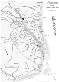
Ģ Plantations of the Lower Cape Fear - PDF
Ģ The Great Wagon Road - PDF

Ģ The Middle Passage - PDF
Ģ Principal Towns by 1820 - PDF
Ģ The American Revolution - PDF
Ģ The Dismal Swamp Canal - PDF

Ģ Slave Population by 1860 - PDF
Ģ Lighthouses and Lifesaving Stations - PDF
Ģ Railroads Ś Principal Lines by 1890 - PDF
Ģ Gold Mining - PDF
Ģ The Civil War - PDF
Ģ Battle of Bentonville - PDF

Ģ Textile Mills - PDF
Ģ Spencer Shops Ś N.C. Transportation Museum - PDF
Ģ The Election of 1900 - PDF
Ģ African American Educational Progress - PDF

Ģ Research Triangle Park - PDF
Ģ The Blue Ridge Parkway - PDF
Ģ World War II - PDF
Ģ Charlotte: Growth by Annexation - PDF
Ģ Highways, ca. 1924 - PDF
Return to Map Gallery

 COPYRIGHT AND CONDITIONS OF USE COPYRIGHT AND CONDITIONS OF USE
Maps ® North Carolina Department of Cultural Resources unless otherwise noted.
All rights reserved.
|