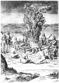
Encampment of American Indians, North Carolina's earliest inhabitants. Theodore De Bry engraving of painting (ca. 1585) by John White.
|


THE FIRST CAROLINIANS . . .
CHAPTER EXCERPTS
 or almost 500 years, people of European and African descent have inhabited a land now called North Carolina. Richly varied, it extends from the eastern edges of the Mississippi River basin in the Appalachian Mountains to the remarkable barrier islands known as the Outer Banks. Mount Mitchell, near the Blue Ridge Parkway in Pisgah National Forest, is the highest elevation in the eastern United States. Here northern hardwoods mingle on the steep slopes with a bewildering variety of southern flowers and shrubs. Less than 500 miles east, at Cape Hatteras, a venerable lighthouse surveys the flat but treacherous coastline. Here the warm waters of the powerful Gulf Stream bring mild, and occasionally stormy, weather to the low-lying coast. Between the rugged Blue Ridge and the broad Coastal Plain, stretching roughly from modern-day Morganton to Raleigh, lie the rolling foothills that colonial settlers called the Carolina Piedmont. or almost 500 years, people of European and African descent have inhabited a land now called North Carolina. Richly varied, it extends from the eastern edges of the Mississippi River basin in the Appalachian Mountains to the remarkable barrier islands known as the Outer Banks. Mount Mitchell, near the Blue Ridge Parkway in Pisgah National Forest, is the highest elevation in the eastern United States. Here northern hardwoods mingle on the steep slopes with a bewildering variety of southern flowers and shrubs. Less than 500 miles east, at Cape Hatteras, a venerable lighthouse surveys the flat but treacherous coastline. Here the warm waters of the powerful Gulf Stream bring mild, and occasionally stormy, weather to the low-lying coast. Between the rugged Blue Ridge and the broad Coastal Plain, stretching roughly from modern-day Morganton to Raleigh, lie the rolling foothills that colonial settlers called the Carolina Piedmont.
Thousands of years before settlers from Europe and Africa set foot on Carolina soil, another people inhabited the land. Termed "Indians" by Christopher Columbus, they were in fact the first Carolinians. Their history encompasses migrations the length and breadth of an immense continent, shattering invasions, and technological transformation. By the time non-Indians reached North Carolina, sound agricultural methods were well in place. Even metalworking was not unknown.

Modern archeologists also think the ancestors of the North Carolina Indians may have migrated from the west. Although their theories vary considerably, most scholars agree on one fact: the predecessors of the American Indians at some time crossed a land bridge between Asia and America. Some say the first crossing, toward "where the sun rises," took place more than 30,000 years ago. Indeed, it could have occurred as much as 70,000 years ago, when the growing glaciers of the last ice age lowered the sea level enough to expose dry land at the Bering Strait. At the peak of the ice age's final phase, about 18,000 years ago, the land bridge from Asia to present-day Alaska may have been 1,000 miles wide. It clearly would have been possible for inhabitants of Asia to reach North America.
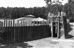
Town Creek Indian Mound and palisade.
|
At Town Creek Indian Mound near Mount Gilead, North Carolina, visitors can view reconstructed remains of the Pee Dee Creek culture. The Creeks chose this high bluff overlooking the Little River for the site of their regional ceremonial center. Basketload by basketload, they hauled earth from nearby fields and a swampy area to the west. Finally, they completed an earthen ceremonial lodge and surrounded it with a palisade of upright logs. After much use, the earthen lodge collapsed. Once again the people of the Pee Dee collected earth, this time to cover the lodge's remains. The mound they created in covering the lodge became the foundation for their next construction: a ceremonial temple. But this building, like the first, was ill-fated. When it burned to the ground, the Creeks covered the remains as they had previously and built a third temple atop the growing earth mound.
This third and final structure is the one visitors can see reconstructed at the site today.
|